Local government office nearby TLScontact Tallinn
Estonia
Local government office nearby TLScontact Tallinn
TLScontact Tallinn
2, Viru väljak, 10111, Tallinn, EE Estonia
contacts phone
:
+372
website:
uk.tlscontact.com
Latitude:
59.437372
, Longitude:
24.7539708
larger map & directions
read more
nearest Local government office
361 m
Ohutu TK OÜ
Kanepi 4, Tallinn
Local government office
read more
487 m
Russia Visa Application Centre
Estonia puiestee 9, Tallinn
Local government office
read more
620 m
Legal Estonia OU
Tornimae 5, 2nd floor, Tallinn
Local government office
read more
665 m
Tallinn Cultural Office
Vabaduse väljak 10, Tallinn
Local government office
read more
760 m
Tallinn City Planning Department
Vabaduse väljak 7, Tallinn
Local government office
read more
768 m
Nunnu kesklinna valitsus
Kentmanni 9-60, Tallinn
Local government office
read more
770 m
Tallinna Ettevõtlusamet
Vabaduse väljak 7, Tallinn
Local government office
read more
774 m
Tallinn City Office Service Bureau
Vabaduse väljak 7, Tallinn
Local government office
read more
783 m
Tallinn City Center Government
Nunne 18, Tallinn
Local government office
read more
977 m
Harju County
Roosikrantsi 12, Tallinn
Local government office
read more
1.39 km
Sotsiaalkindlustusameti Tallinna klienditeenindus
Endla 8, Tallinn
Local government office
read more
1.423 km
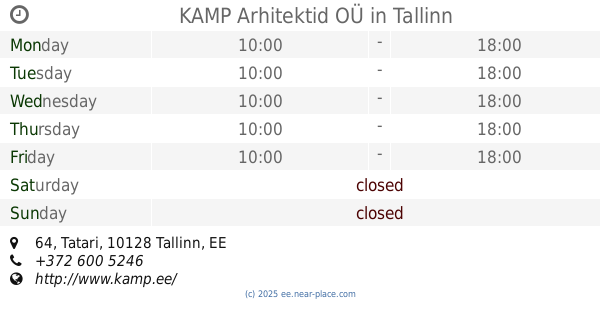
KAMP Arhitektid OÜ
Tatari 64, Tallinn
Local government office
read more
1.435 km
Tallinn Vital Statistics Department
Pärnu maantee 67, Tallinn
Local government office
read more
1.461 km
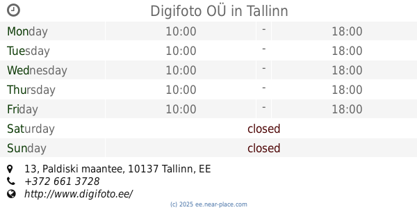
Digifoto OÜ
Paldiski maantee 13, Tallinn
Local government office
read more
24.093 km
Keila Social Center
Pargi 30-3
Local government office
read more
48.05 km
Sotsiaalkindlustusamet
Tallinna maantee 14
Local government office
read more
48.443 km
Aire Tammik Driving School LLC
Tallinna mnt 33
Local government office
read more
📑
all categories
Accounting
Administrative area level 1
Administrative area level 2
Airport
Amusement park
Art gallery
Atm
Bakery
Bank
Bar
Beauty salon
Bicycle store
Book store
Bowling alley
Bus station
Cafe
Campground
Car dealer
Car rental
Car repair
Car wash
Casino
Cemetery
Church
City hall
Clothing store
Colloquial area
Convenience store
Country
Courthouse
Dentist
Department store
Doctor
Electrician
Electronics store
Embassy
Establishment
Finance
Fire station
Florist
Food
Funeral home
Furniture store
Gas station
General contractor
Grocery or supermarket
Gym
Hair care
Hardware store
Health
Home goods store
Hospital
Insurance agency
Jewelry store
Laundry
Lawyer
Library
Light rail station
Liquor store
Local government office
Locality
Locksmith
Lodging
Meal delivery
Meal takeaway
Mosque
Movie theater
Moving company
Museum
Natural feature
Neighborhood
Night club
Painter
Park
Parking
Pet store
Pharmacy
Physiotherapist
Place of worship
Plumber
Point of interest
Police
Post office
Premise
Real estate agency
Restaurant
Roofing contractor
Route
Rv park, camping
School
Shoe store
Shopping mall
Spa
Stadium
Storage
Store
Subpremise
Supermarket
Synagogue
Taxi stand
Train station
Transit station
Travel agency
University
Veterinary care
Zoo
sublocality level 1
↑